
Thursday, 17 November 2016
Homeward
On the way home, I stopped at another Bora ring. This was at the top of a flat hill that is now being used as a cemetery, although the main Bora ring is still separate.
Wednesday, 16 November 2016

Tuesday, 15 November 2016
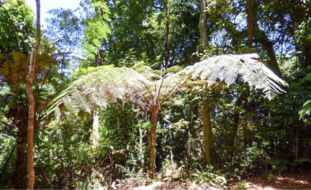
River Rainforest
I was lucky to go on a river rainforest cruise. Most of the coastal rainforest has been changed into banana plantations, sugar cane and other agricultural land, but a small amount beside the Noosa River and some of its tributaries is the largest area of pristine subtropical riverine rainforest in Australia. It abounds in native palms, and other endangered rainforest plants and animals.


Monday, 14 November 2016
Gondwanaland Beaches
When you go to the beach for a holiday, you are actually supposed to visit the beach itself - particularly when you are at one of the best beaches in the world. After all, the Gold Coast is known throughout the world, and here I am, within easy walking distance. It can't be more than 100 metres away, at the end of the street. There is actually a reserve that surrounds us, which has the highest koala in somewhere - NSW? Australia? the northern NSW coast? - anyway, I have even seen a few without even trying. So it is a pretty impressive place even without the Gondwanaland World Heritage areas.


So today I visited the beaches, and when I get home you will see that they are very nice indeed.
But the beaches also have the occasional rocky headland interrupting beach almost as far as the eye can see. These headlands are really interesting because they are part of the Mount Warning volcano. At Fingel's Head, there is a tessilated pavement, called the Giants Causeway. At Hastings Point there is another basalt headland. So, even the coastline itself is part of the volcano.
I also went to the Aboriginal cultural centre. The museum was shut because they were away for two weeks training, but the bora ring (original) and the mangrove walk and boardwalk were still open, and they were very good.
Border Ranges
Border Ranges National Park is in New South Wales, but on the border with Queensland. There are a number of lookouts from the park over to Mount Warning  and towards Queensland (the Lost Forest which is the largest area of subtropical rainforest wilderness in Australia - it includes Lamington National Park).
The roads through the park are really nice - at one stage I was surrounded by butterflies for several kilometres. There are a number of walks, which explore different plant communities, and show the diversity of plant life in the park. Obviously not many people go on most of the paths as they were a bit overgrown, but maybe it's just that everything grows fast. I really enjoyed the park, and it was a pity that I couldn't do everything. You really need to stay there.
I visited Lions Road, which was created by the Lions clubs of Beaudesert and Kyogle to join the two communities. It goes through the park, and has a lookout overlooking the Border Loop Railway doing a complete circuit of a hill to increase its altitude by 30 metres to make the grade of the railway much smoother (the railway starts wide, goes through two tunnels in the hill, and crosses over itself to continue on to Brisbane). When it was completed in 1930 it allowed standard gauge interstate trains. One tunnel is actually built through the border between NSW and Queensland.
Sunday, 13 November 2016
Natural Bridge
Natural Bridge National Park is what you would expect around here - semitropical rainforest. The car said 35 degrees when I stopped, and within moments of going into the rainforest I was dripping - but what else would you expect?


It is absolutely amazing. There were lots of people there - more than 30 cars and a minibus of Chinese tourists. Although it's close to Brisbane the roads are steep and windy and narrow, so I wouldn't have expected so many. There is a circuit which doesn't take long. There is a Waterfall that plunges into a hole, and comes out, so the bridge is formed. In the cave the Waterfall is illuminated by sunlight during the day. At night there are glow worms for illumination. And there are bats. And there is rainforest that you can see on the other side of the bridge. It is just beautiful.
After seeing that, I went to Lamington National Park. There is a long road up the side of the mountain with numerous switchbacks and blind corners and places where the road is only one lane. Of course, I was going up in the late afternoon when everyone else was going down. It was really nice, with numerous views across the country, some to Mount Tamborine which is opposite it. And I was back into dry rainforest, although I think Mount tambourine is wet rainforest.
West Gondwanaland
Mount Warning dominates this part of New South Wales and Queensland. It was the central plug of a volcano that existed when Gondwana was intact, that some say is the largest terrestrial volcano in the world. It extended from Tenterfield to the coast, and is responsible for the extensive rock formations around here. Also, the soil formed from the volcano was very fertile and caused the Gondwanaland World Heritage areas to become a highly diverse part of the world (note that biodiverse hotspots are terms for significant environments that are under threat, which is why Australia has no hotspots, even though we have a number of significant biodiverse places).


Today I went towards Tenterfield to see the more westerly World Heritage parts. These are "dry rainforests" and include the Richmond Ranges National Park. Access to this is via a dry weather road running along a ridge to the park itself. Unfortunately as soon as I reached the walking tracks, the sky's opened, and a violent thunderstorm erupted. So, I beat a hasty retreat, before the road absorbed the moisture and became impassable.
However, a bit later on I came across the Bean Creek Waterfall. On my way out, another was coming down the very overgrown path, asking whether there was any water - they had evidently been several times, and it had always been dry.
Friday, 11 November 2016
Waterfall Way
From Armidale you can travel along Waterfall Way to the coast. This includes Oxley Wild Rivers National Park, Guy Falkes River National Park, New England National Park and Cathedral Rock National Park. I recall that the first two are part of the Gondwanaland World Heritage Area.


I visited two waterfalls in Oxley - Chandler Falls and Wollomombi Falls (second highest in Australia), and Ebor Falls in Guy Falkes. I also visited Cathedral Rock, but I didn't see anything there, except the traces of a very recent bushfire. The walk to the rock would have taken a few hours, and I just didn't have the time.
Then I departed Waterfall Way and went to Grafton rather than Coffs Harbour. The road was very interesting, going through temperate rainforest with lots of tall tree ferns, but it was very winding and narrow. It went through grates, and in the middle of a National Park, there was a bull on the road amongst the hairpin bends. No wonder the two cars going the other way had blinked me!
The Pacific Highway was even worse, as they are duplicating it from about Grafton to Bellina, and. There was a never ending stream of cars in both directions.
Cappertee
It was foggy when I woke, so I ventured down the weir track, but didn't go all the way, because it was really difficult to see anything much - although I did see a platypus and a number of birds.


I went back toward Lithgow, and visited Pearsons Lookout. At Lidsdale, I turned off to go to Newnes (another campground in Wollemi National Park, also the site of historical ruins). On the way, the Gardens of Stone National Park is on both sides. You drive between two escarpments, and the entire route is fantastic. There were about 10 people camped already, even though it was still morning.
I skirted the top of Wollemi park on my way north, and you really get an understanding of why it took 25 years from settlement until they found a way into the interior. The Great Dividing Range is probably one of the shortest in the world, but all through NSW and a lot of Victoria, it is very broken and difficult to negotiate. Melbourne is lucky that it's located at about the easiest place to go inland. I ended the day at Armidale.
Dunn's Swamp
Years ago I heard that we had a canyon bigger than the Grand Canyon - Capertee. So today I took the road around the bottom of the canyon. Unfortunately it was raining, so I couldn't get photos, but in the morning I'll get a panorama from Mount Pilot, which overlooks it.


Tonight I'm staying at Dunn's Swamp, a National Park campground in Wollemi National Park, which is extraordinary! It has beehive shaped rocks (very weathered like the Bungle-Bungles, but called pagodas), which also have some Aboriginal Rock Art on them, and the campground surrounds the rocks. There is also the weir, and people canoe and fish here. It's very popular, and there must be at least 30 people here.
There are two easy walks - the campsite loop which goes around the pagodas, and the weir walk. Tonight I did the campsite walk and saw several of the wallabies, kookaburras and a lot of other birds.
Tuesday, 21 June 2016
Dr Sun Yet-Sen Classical Chinese Garden
I found out that Vancouver has the world's best city garden according to National Geographic. So on my last morning I walked to it.


It is located in Chinatown, which has a different pair of lions at its gate (but these are not from a sister city).
I was there when they were feeding the koi.
The water is not dirty, it is deliberately jade green.


They were having an exhibition of the first artists to exhibit there, which included some painted rocks.
The city of Vancouver built a complimentary garden next door.
It really is a stunning garden!
Then I went back to the hotel, stopping at the library which was opposite.
Saturday, 18 June 2016
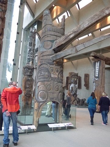
Definitely the Last Totem Poles
As the market here is supposed to be one of the best in the world, I decided to catch the ferry in False Creek, and visit Granville island on the first leg of today's mamouth journey. The boats looked just like the pickle boats in Victoria, and evidently the person who designed them also designed these.


The market had a good range of raw food, cooked food and other items, but it was a bit squashed as it was Saturday, and raining. It rained or poured all day.
Then I caught the ferry on to the Museum of Vancouver, which recounts the history of Vancouver from the first people to the 1970s. It was really interesting, especially the Asian history, including the anti-Chinese and Indian laws in the early 1900s and the Japanese internment during and after the Second World War.
Then I walked to the bus, and caught it to the Museum of Anthropology at the university of British Columbia. This had been recommended to me by various people, including Ginnie, and it was very good - so good that it closed before I had finished looking at its displays, even though I had been there for three hours.
On the walk through UBC I saw the rose garden, and several couples getting wedding photos in it.
I caught a different bus and returned to the hotel, damp but satisfied.
Vancouver
Well, there was sunshine this morning on the ferry.
I misread the timetable again, and thought we were leaving the ferry two hours after we were, but that was easily solved, as the PA announced our arrival in an hour, and the purser knocked on my door...
The train to Vancouver was nice, but every time I took a picture, trees got in the way.
It was a nice walk to the hotel via the stadium and the sea wall. I really like Vancouver. The hotel has lots of eateries around it, a free breakfast, and really cheap laundry facilities as well as being an enormous suite! I wandered around the streets for a while, but didn't see much.
Well, maybe not...
I didn't realise we were stopping in Ketchikan when I wrote the last post, and Ketchikan prides itself on being the totem pole capital.


To get into town, I had to catch the bus.
They have several collections of totem poles, apart from the ones scattered randomly throughout the town. Saxman native village (south 5 miles from the ferry) has a thriving totem pole culture, as well as some original poles. Totem Bright state park (north 7.5 miles from the ferry) has a long house and some totem poles, but no carvers. The Totem Heritage Centre (north 2.5 miles from the ferry, near downtown) has really old poles that were rescued from several villages in the Ketchikan area, remade versions and an interpretive centre. Obviously, that was the one I visited. It was small and crowded (two cruise ships were in), but very good. There were guides to answer any question you had about totem poles, and they were excellent.
I walked along the creek (married men's trail goes to the original red light district), had lunch there and walked all the way back to the ferry.
Then I went to the museum.
There were a number of totem poles around the town, especially Chiefs totem poles.
The land is very steep, and houses have multiple steps to their front doors.
To get to the airport, people need to take a ferry, which stopped working while I was there.i came back a the lift in my ferry is going to be out for the rest of the trip.
Subscribe to:
Comments (Atom)